Sudan
|
Population
Flag The flag of sudan incorporates the colours of red, green and black. The red band symbolizes Sudan's struggle for liberation. The white color is the sign of brightness, harmony, and hope. The black color represents the country itself. The green colour is the symbol of Islam, the affluence of the nation, and cultivation . Climate Sudan has a tropical climate. Summer temperatures often exceed 43.3 degrees Celsius in the desert zones, and rainfall is negligible. Dust storms frequently occur in the desert zone. High temperatures also occur in the south throughout the central plains region, but the humidity is generally low. In Khartoum the average annual temperature is about 26, 7° Celsius and annual rainfall, most of which occurs between mid-June and September, is about 254 mm. Facts Located in northeast Africa, Sudan is the largest country on the continent. It is about a quarter of the size of the United states (2,505,813 sq km), making it the 10th largest country in the world according to the World Factbook. With the Red Sea taking up approximately 853 km of its northeastern border, other Sudanese neighbours include: Central African Republic, Chad , Democratic Republic of the Congo, Egypt, Eritrea, Ethiopia, Kenya, Libya, and Uganda. 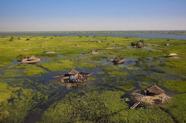
Sudd
|

Travel warnings
Flora and fauna Vegetation is extremely sparse in the northern desert areas, with most of the substantial forests to be found in central and southern regions. Savannah-type elephant grass covers much of the central region. The river valleys are home to a wide variety of trees, such as acacia, ebony and baobab. Cotton, papyrus, rubber and castor-oil plants are also indigenous to the Nile Basin. Animals in the southern region include elephants, lions, cheetahs, zebras, hippopotami, buffalo, antelope, rhinoceros, giraffe, various breeds of monkey, crocodiles and a large variety of tropical birds. Things to do
|
Uganda
|
Population
The Ugandan flag has six equal horizontal bands of black, yellow and red. The black represents the African people, yellow= sunshine and vitality, red= African brotherhood Climate and geography Uganda, twice the size of Pennsylvania, is in East Africa. It is bordered on the west by Congo, on the north by the Sudan, on the east by Kenya, and on the south by Tanzania and Rwanda. The country, which lies across the equator, is divided into three main areas—swampy lowlands, a fertile plateau with wooded hills, and a desert region. Lake Victoria forms part of the southern border. Travel warnings
|

Facts
Culture and sports Belonging to many ethnic groups, Ugandans speak over 30 different African languages. English and Swahili are the country’s official languages. Things to do 1. Murchison falls- Murchison Falls National Park is a national park in Uganda in the northwestern of Uganda, spreading inland from the shore of Victoria nile 2. Mandela national stadium- Mandela National Stadium is a multipurpose stadium in Kampala, Uganda. It is currently used mostly for football matches, although other sports are also practiced. The stadium has a capacity of 40,202 people. The stadium was built with a grant of $36 million dollars from the People's Republic of China. 3. Bujagali falls- Situated about 10km from central Jinja, Bujagali is not an actual waterfall, but rather a widespread series of large rapids, and was once one of Uganda’s outstanding natural beauty spots |
Tanzania
|
Population
Flag The national flag of Tanzania comprises of four colours; green, yellow, black and blue. The green represents the natural resources in Tanzania, the yellow represents the natural mineral deposits, the black represents the people of Tanzania and the blue represents the bodies of water in Tanzania. Climate and geography Tanzania has a pleasant tropical climate but has large regional climatic variations influenced by several factors, including altitude. Temperatures drop by about 6.5°C for every 1000m you climb . The hottest and most humid part of the country is on the coast. Other low lying areas, such as the western and southern parks, are also hot but much less humid. The rest of the interior is much milder and cools down significantly at night. Tanzania is too close to the equator to experience a real winter and summer. Travel warnings
|
Things to do
1. Mount Kilimanjaro- Mount Kilimanjaro is one of the world's most accessible high summits, attracting visitors from around the world 2. Mafia Island- Mafia Island is the largest of a small archipelago of islands and atolls and is truly a paradise in the Indian Ocean. It is the southern most of three islands (Pemba & Zanzibar) located off the coast of Tanzania. The resident population of 46,000 are mainly fishermen or smallholder farmers that grow coconut, paw-paw, rice and cassava. The islanders are friendly and welcoming and the atmosphere relaxed and laid-back. 3. Lake Victoria 
Mount kilimanjaro-peaks

Culture
The most important contribution towards the culture of Tanzania is it's variety in languages. More than 100 languages are spoken in this country. |
Mozambique
|
Population
Facts
The Mozambique flag consist of 5 colours including:
|

Travel warnings
The weather along the coast of Mozambique is sunny and warm even in coarse midwinter which is chilling elsewhere. In summers the months ranges from October to April which is rainy, humid, and very hot. The winter months, from April to September are cooler and drier and thus provide the most comfortable tenure for travel. Things to do Quirimbas Islands- The Quirimbas Islands lie in the Indian Ocean off north-eastern Mozambique, close to pemba, the capital of the province of cabo De-gelego. The archipelago consists of about 32 islands, including ibo, Matemo, Medjumble Quirimba Metundo, Quisiva Vamizi Islands and rolas islands all going up to the Tanzanian border Bazaruto Archipelaho- The Bazaruto Archipelago is a group of six islands in Mozambique, near the mainland city of Vilankulo. It comprises the islands of Bazaruto, Benguerra, Magaruque, Banque, Santa Carolina and Shell. Nyati Island locates in further south |
